When it comes to exploring Mars, finding water is the holy grail. It’s not only essential for future human colonies—it also holds clues about the planet’s ancient climate and potential for life. But spotting underground ice from orbit is tricky; rovers need precise drilling locations to avoid wasting precious energy. Now, a breakthrough technique using drone-mounted radar flown over glaciers on Earth is showing how we can map buried ice in incredible detail, offering a game‑changing tool for future Mars spacecraft. Here are eight things you need to know about this innovative approach.
1. The Challenge of Finding Subsurface Water on Mars
Mars’s surface is dry and dusty, but vast amounts of water ice lie hidden beneath its crust—especially in mid‑latitude regions like Arcadia Planitia. Orbital radar can detect that ice, but not in high enough resolution to pinpoint a safe drilling site. A rover might hit rocks, clathrates, or a thin ice layer instead of the pure, drinkable water needed for life support or fuel production. That’s why scientists are testing drone radar on Earth: to see if they can achieve the meter‑scale resolution required to guide a drill. The goal is to map not just the presence of ice, but its depth, purity, and layering. Only then can a mission confidently send a drill to the right spot without wasting time on dead ends.

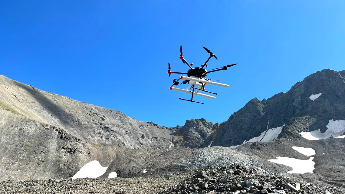
2. How Drone-Mounted Radar Works
Ground‑penetrating radar (GPR) systems transmit radio waves that bounce off subsurface features. When mounted on a drone, the radar can fly close to the ground—just a few meters up—giving it a much sharper signal than orbital instruments. The drone follows a grid pattern, emitting pulses that penetrate ice, snow, and soil. Reflections from buried objects or density changes (like the interface between ice and rock) are recorded and stitched together into 3D models. The key innovation is the drone’s ability to access rugged terrain that rovers or humans cannot easily reach, and to do so quickly without disturbing the landscape. On Earth’s glaciers, this setup has already revealed buried ice features as small as a few meters across—a resolution that could be a game‑changer for Mars drilling.
3. Testing on Earth's Glaciers: A Natural Laboratory
Earth’s glaciers are excellent analogs for Martian polar and mid‑latitude ice deposits. They contain layers of pure ice, dust, and rocky debris, similar to what we expect on Mars. In a recent study, researchers flew a quadcopter drone over two glaciers in British Columbia and Alaska (the Matanuska and Athabasca glaciers) using a custom GPR system. The drone hovered at around 10 meters altitude, collecting data over several square kilometers. The result: high‑resolution maps showing ice thickness, internal layers, and even buried crevasses. Crucially, the drone could distinguish between clean ice and sediment‑rich ice—a distinction that will matter when choosing where to drill for water that requires minimal processing. The success of these test flights confirms that the same technique could work on Mars.
4. Mapping Buried Ice in Unprecedented Detail
The drone radar produced images with a vertical resolution of about 20 centimeters and horizontal resolution of roughly 1 meter. That’s a huge leap from orbital radar, which typically resolves features only tens of meters across. This level of detail allows geologists to see thin ice layers, the exact depth of the ice table, and even underground meltwater channels. For Mars, this could help identify the best locations for drilling water ice that is pure enough to be melted for drinking or electrolyzed for rocket fuel. The drone’s ability to fly at low altitude also means it can observe features that might be obscured by surface dust or seasonal frost. In essence, drone radar gives us a “CT scan” of the shallow subsurface—something no rover can do on its own.
5. Why Precision Drilling Matters for Mars Missions
Drilling on Mars is expensive and risk‑heavy. A single drilling attempt could take weeks, using power that could otherwise run scientific experiments. If you drill in the wrong spot—say, into a layer of brine or dusty ice—you might get water that’s tainted with salts or perchlorates (harmful to both humans and equipment). Worse, you could hit a dry layer and waste the mission. The drone radar technique would allow a spacecraft to first map the landing zone from orbit, then send a low‑altitude drone (like a Mars helicopter) to refine the map with meter‑scale precision. Only after this “radar survey” would the rover move to a prime drilling location. This reduces risk and maximizes the chance of striking clean water ice. Future missions like NASA’s Mars Ice Mapper or the Mars Sample Return campaign could benefit immensely from such targeted drilling.
6. The Role of Analog Environments
Testing in Earth’s glaciers is crucial because it allows scientists to validate the radar’s penetration and resolution in real‑world conditions. They can also ground‑truth the data by drilling core samples at the same sites. For instance, after the drone flight over the Athabasca Glacier, researchers drilled several boreholes to compare the radar reflections with actual ice stratigraphy. The match was excellent, confirming that the technique yields reliable results. This kind of validation is impossible on Mars until we send a mission, so Earth analogs provide the essential proof‑of‑concept. Future tests could include flying drones over ice in Antarctica, or even over simulated Martian terrain in the Arctic, to further refine algorithms for processing radar data on another world.
7. From Earth to Mars: Adapting Technology
The drone radar hardware used on Earth is not yet ready for space. It’s heavy, requires battery life that Mars’s thin atmosphere cannot support, and isn’t designed for the extreme cold and radiation. But the concept is scalable. Scientists envision a Mars drone—similar to NASA’s Ingenuity helicopter but larger and more powerful—carrying a lightweight GPR system. It would fly in short hops (a few kilometers per day), recharging with solar panels. The drone would need to operate autonomously, mapping a 1‑km² area in a few flights. The radar frequencies would be adjusted to penetrate Martian ice (which is colder and drier than Earth ice). Data would be relayed back to a lander or rover for real‑time processing. While challenges remain, the Earth tests prove the physics works. A Mars drone radar could be ready within the next decade.
8. Future Implications for Human Exploration
Reliable access to water is the linchpin of any sustained human presence on Mars. Water is not just for drinking—it’s for oxygen, fuel (via splitting into hydrogen and oxygen), and even radiation protection. The drone radar technique could also map subsurface ice for building habitats (e.g., using 3D‑printed ice walls). Moreover, the same radar could be used to find caves or lava tubes for shelter. On a larger scale, the technology could be deployed by robotic missions pre‑pluming potential colony sites. The recent success on Earth’s glaciers thus marks an important step toward turning science fiction into reality. As one researcher put it, “We have the tool; now we need to send it to Mars.” With continued development, drone radar could help humanity choose exactly where to drill for the water that will sustain life on the Red Planet.
Conclusion
The marriage of drone technology and ground‑penetrating radar is giving scientists a new set of eyes to see hidden water ice—first on Earth, soon on Mars. By proving that low‑altitude, high‑resolution surveys can map buried ice in stunning detail, this research brings us closer to the day when future astronauts can land on Mars with confidence, knowing exactly where to drill for the most precious resource of all. The next step is to adapt the system for space and test it in even more extreme environments. One thing is certain: the path to Martian water runs right through Earth’s glaciers.